Mammoth Mountain
 Weekend Getaways
AllGetaways.com
Mountain Biking
Trails.com
Golf Courses
GolfLink.com
Running
RunThePlanet.com

This page is unfortunately closed.
Mountain Bike - Mountain Biking - Trails
|
Founded and maintained by dedicated mountain biking enthusiasts, Mountain Bike Resources (MBR Online) has everything any mountain biker could need. Since its founding at the dawn of the "Internet Age," Mountain Bike Resources has been the leader in online mountain biking information, providing trail descriptions, the scoop on great mountain biking destinations, mountain bike equipment reviews, and much more. So when you're not looking over your handlebars at a great stretch of singletrack, looking at the information on Mountain Bike Resources might be the next best thing.

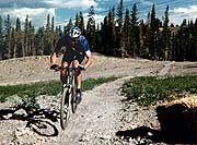
Experiences From our Mountain Biking Roadtrip
Come with us as we discover some of the best
mountain biking trails in California's Sierra
Nevada Mountains.
Mountain Bike Trails
Mountain bike trails in every state, with trail descriptions, photos, maps, and more.
Mountain Bike Destinations
Mountain bike ride reports from the US and around the World, including top riding destinations like Hood River Oregon, Park City Utah, Rock Creek California, and Marin County (Mount Tamalpais) California.
Mountain Bike Meccas
Information on the top U.S. mountain biking destinations, detailing great mountain bike trails in places like Moab, Utah, Crested Butte and Durango, Colorado, Lake Tahoe, California, and Sun Valley, Idaho, including historical information, directions, maps, ride infomation, and more.
Mountain Bike Scene
Mountain biking news, equipment reviews, and trip reports, all written by knowledgeable professionals and covering a range of topics of interest to mountain bikers of all abilities.
Mountain Bike Directory
Comprehensive nationwide directories of bike stores, mountain biking clubs, bicycle manufacturers, mountain bike tour operators, and other related services and groups.